信息通信技术与政策

信息通信技术与政策

信息通信技术与政策 ›› 2026, Vol. 52 ›› Issue (4): 53-63.doi: 10.12267/j.issn.2096-5931.2026.04.007

专题:低空经济 上一篇    下一篇

面向低空应急救援的多维态势感知与无人机集群智能协同管控技术研究

Research on multi-dimensional situational awareness and intelligent collaborative control technology for UAV swarms in low-altitude emergency rescue

张恩皖1, 张其强2, 戴明艳1, 徐航1, 何文豪1   

  1. 1.中国移动通信集团安徽有限公司, 合肥 230088
    2.中移(上海)信息通信科技有限公司, 上海 200131
  • 收稿日期:2026-03-20 出版日期:2026-04-25 发布日期:2026-04-24
  • 通讯作者: 张其强 中移(上海)信息通信科技有限公司工程师,长期从事交通系统设计与控制、智能交通等领域的研究工作
  • 作者简介:
    张恩皖 中国移动通信集团安徽有限公司高级工程师,长期从事大数据分析、建模挖掘、智能网联、量子通信等方面的研究工作
    戴明艳 中国移动通信集团安徽有限公司高级工程师,长期从事无线网络优化、大数据分析、低空通信、车路云一体化等研究工作
    徐航 中国移动通信集团安徽有限公司高级工程师,长期从事大数据分析、市场营销、智能网联、通信技术等方面的研究工作
    何文豪 中国移动通信集团安徽有限公司工程师,长期从事低空经济、智能网联、5G通信等方面的研究工作

ZHANG Enwan1, ZHANG Qiqiang2, DAI Mingyan1, XU Hang1, HE Wenhao1   

  1. 1. China Mobile Group Anhui Co., Ltd., Hefei 230088, China
    2. China Mobile (Shanghai) ICT Co., Ltd., Shanghai 200131, China
  • Received:2026-03-20 Online:2026-04-25 Published:2026-04-24

摘要:

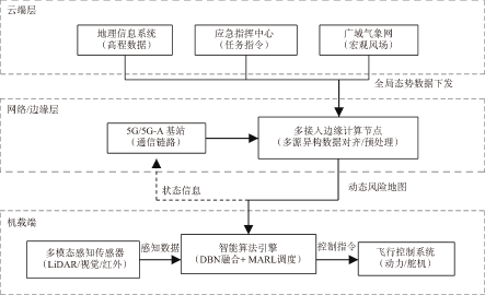
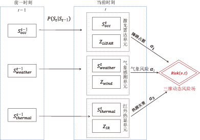
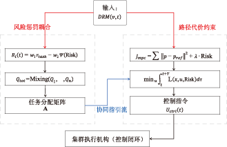
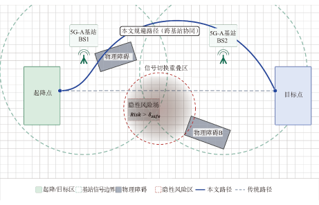
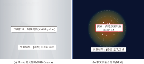
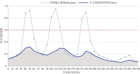
针对低空应急救援场景中环境复杂多变、多机协同调度困难及动态风险规避能力不足的问题,提出了一种融合多维态势感知的无人机集群智能协同管控技术。通过构建基于动态贝叶斯网络的异构信息融合模型,将机载传感数据与外部时空态势映射为三维动态风险地图。在此基础上,设计了风险耦合的多智能体强化学习调度策略与自适应路径规划方法,将量化风险值实时引入决策与规划闭环。外场试验结果表明,该方法能够显著提升对动态风险的感知精度,能够在复杂动态环境下有效提高无人机集群的任务成功率,缩短平均避障响应时间与任务完成总耗时,降低平均风险暴露时长,为构建安全高效的低空应急救援体系提供技术支撑。

关键词: 低空应急救援, 多维态势感知, 无人机集群, 智能协同管控, 动态贝叶斯网络

Abstract:

Targeting the challenges of complex and volatile environments, difficulties in multi-Unmanned Aerial Vehicle(UAV) coordination, and insufficient dynamic risk avoidance in low-altitude emergency rescue, An intelligent collaborative control technology based on multi-dimensional situational awareness is proposed. By constructing a heterogeneous information fusion model based on dynamic bayesian networks, airborne sensor data and external spatio-temporal situational data are mapped into a 3D dynamic risk map. On this basis, a risk-coupled multi-agent reinforcement learning scheduling strategy and an adaptive path planning method are designed, to integrate real-time risk quantification into the decision-making and planning loop. Field experiments demonstrate that this method significantly improves the perception accuracy of hidden dynamic risks, increases mission success rate, shortens obstacle-avoidance response time and overall mission completion time, and reduces risk exposure duration in complex environments, thereby providing technical support for safe and efficient low-altitude emergency rescue systems.

Key words: low-altitude emergency rescue, multidimensional situational awareness, UAV swarm, intelligent collaborative control, dynamic bayesian network

中图分类号: