信息通信技术与政策

信息通信技术与政策

信息通信技术与政策 ›› 2026, Vol. 52 ›› Issue (4): 39-43.doi: 10.12267/j.issn.2096-5931.2026.04.005

专题:低空经济 上一篇    下一篇

基于低空数字孪生的风险量化评估与安全航线规划应用研究*

Research on risk quantification evaluation and safe route planning based on low-altitude digital twins

孙建龙   

  1. 中国联合网络通信有限公司智能城市研究院, 北京 100048
  • 收稿日期:2026-03-09 出版日期:2026-04-25 发布日期:2026-04-24
  • 作者简介:
    孙建龙 中国联合网络通信有限公司智能城市研究院工程师,主要从事智慧城市数字孪生、数字航路网等方面的研发及项目管理工作
  • 基金资助:
    *国家重点研发计划项目(2024YFF0617400)

SUN Jianlong   

  1. Smart City Research Institute, China Unicom Co., Ltd., Beijing 100048, China
  • Received:2026-03-09 Online:2026-04-25 Published:2026-04-24

摘要:

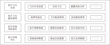
针对当前低空空域管控不足、风险评估不精细、航线规划缺少安全性评估等问题,提出基于低空数字孪生的风险量化评估与安全航线规划技术框架。以北斗网格为基准,对低空空域及环境要素进行管理,建立“地面-空中”融合的风险量化模型,同时基于风险量化评估结果和改进A*算法生成低空飞行航线,并在河南某典型城市开展现场试验,验证了技术的有效性,可为低空空域高效利用和航线规划提供支撑。

关键词: 北斗网格, 风险量化评估, 航线规划, 改进A*算法

Abstract:

To address the current problems of inadequate low-altitude airspace management, imprecise risk assessment, and the lack of safety evaluation in route planning, this paper proposes a technical framework for risk quantification assessment and safe flight route planning based on low-altitude digital twins. Using the BeiDou grid as a reference, the framework manages low-altitude airspace and environmental elements, establishing an integrated ground-air risk quantification model. Based on the results of risk assessment and an improved A* algorithm, low-altitude flight routes are generated. Field experiments are conducted in a typical urban area in Henan Province, validating the effectiveness of the proposed technology. This approach provides support for the efficient utilization of low-altitude airspace and route planning.

Key words: BeiDou grid, risk quantification assessment, route planning, improved A* algorithm

中图分类号: