Information and Communications Technology and Policy ›› 2026, Vol. 52 ›› Issue (4): 39-43.doi: 10.12267/j.issn.2096-5931.2026.04.005
Previous Articles Next Articles
SUN Jianlong
Received:
Online:
Published:
Abstract:
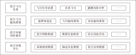
To address the current problems of inadequate low-altitude airspace management, imprecise risk assessment, and the lack of safety evaluation in route planning, this paper proposes a technical framework for risk quantification assessment and safe flight route planning based on low-altitude digital twins. Using the BeiDou grid as a reference, the framework manages low-altitude airspace and environmental elements, establishing an integrated ground-air risk quantification model. Based on the results of risk assessment and an improved A* algorithm, low-altitude flight routes are generated. Field experiments are conducted in a typical urban area in Henan Province, validating the effectiveness of the proposed technology. This approach provides support for the efficient utilization of low-altitude airspace and route planning.
Key words: BeiDou grid, risk quantification assessment, route planning, improved A* algorithm
CLC Number:
V355
SUN Jianlong. Research on risk quantification evaluation and safe route planning based on low-altitude digital twins[J]. Information and Communications Technology and Policy, 2026, 52(4): 39-43.
Add to citation manager EndNote|Ris|BibTeX
http://ictp.caict.ac.cn/EN/10.12267/j.issn.2096-5931.2026.04.005